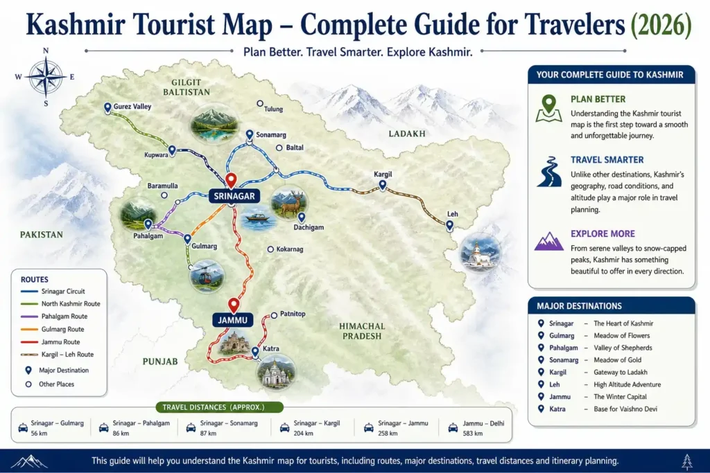
Kashmir Tourist Map – Complete Guide for Travelers (2026)
Planning a trip to Kashmir is like trying to pick a favorite star in a clear night sky, because everything shines in Jammu and Kashmir. Understanding the Kashmir tourist map is the first step toward a smooth and unforgettable journey. Unlike other destinations, Kashmir’s geography, road conditions, and altitude play a major role in travel planning.
This guide will help you understand the Kashmir map for tourists, including routes, major destinations, travel distances and itinerary planning.
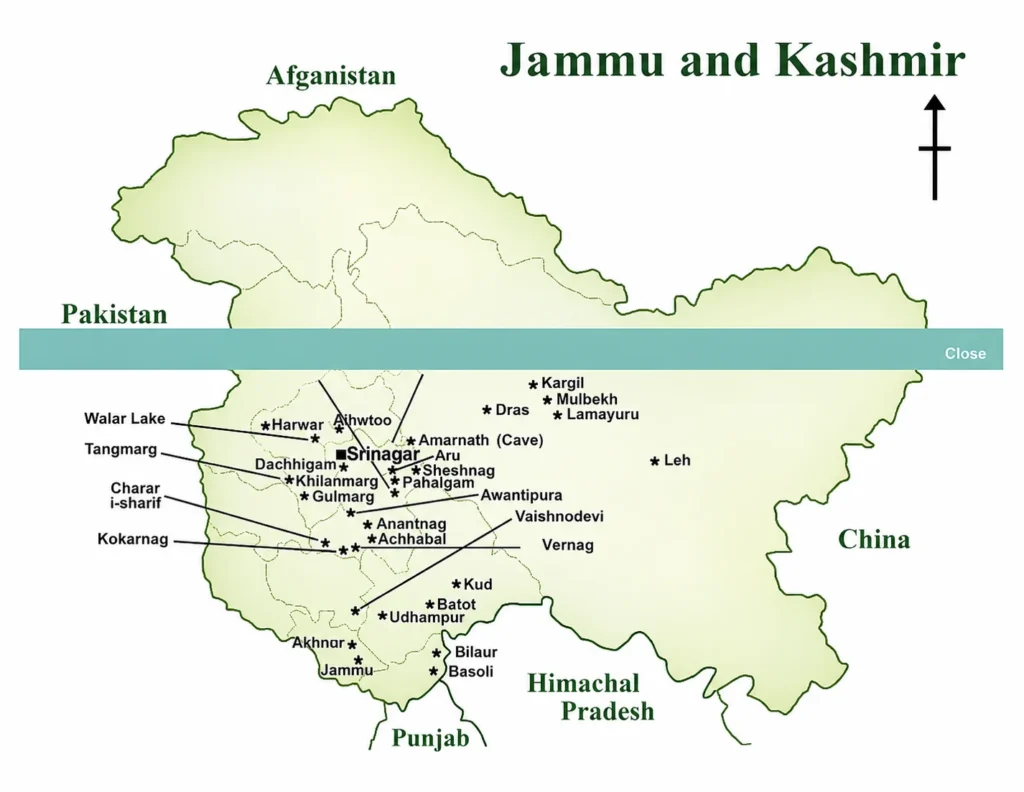
About Jammu & Kashmir Tourism Map
Our Jammu & Kashmir travel map provides complete details of popular tourist attractions across the region, including their exact locations, distances between destinations and proximity to the nearest airport, bus stand and railway station. It also offers valuable insights into Jammu & Kashmir tourism, helping you plan your trip efficiently and explore the region with ease.
Plan your route with our distance calculator for the whole trip.
Kashmir Tourist Map Overview
The erstwhile state of Jammu and Kashmir consisted of three divisions: Jammu, Kashmir and Ladakh. In 2019, the state was reorganized into two Union Territories: Jammu and Kashmir, and Ladakh. The Union Territory of Jammu and Kashmir has two capitals Srinagar (summer capital) and Jammu (winter capital). Jammu and Kashmir is renowned for its natural beauty, and the famous Amarnath Yatra makes the region one of the most important tourist destinations in India.
Major Tourist Destinations on Kashmir Map
Every year, thousands of tourists visit Jammu and Kashmir. Some of the most important tourist attractions include Srinagar, Gulmarg, Sonmarg, Pahalgam, Patnitop, Mansar Lake, Leh, Nubra Valley and Pangong Lake. Srinagar is known for its beautiful lakes such as Dal Lake, Nigeen Lake, and Anchar Lake, as well as its iconic houseboats, while Jammu is famously known as the “City of Temples.”
Apart from these popular destinations, visitors can also enjoy a variety of adventure activities like trekking, skiing, paragliding, and river rafting. For food lovers, especially non-vegetarians, Kashmir is a paradise, as it is renowned for its traditional Wazwan cuisine.
If you are traveling or planning a trip to Jammu and Kashmir, whether alone or by private car, a detailed map of Jammu and Kashmir can help you easily locate important destinations.
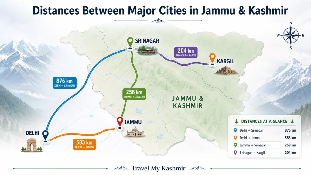
Distance Guide for Jammu & Kashmir Travel
Distances Between Major Cities in Jammu & Kashmir
Understanding distances between major cities and tourist destinations is essential for planning a smooth trip to Jammu & Kashmir. Srinagar is located approximately 876 km from Delhi, 258 km from Jammu and 204 km from Kargil, making it a central hub for exploring the Kashmir Valley. Jammu, on the other hand, lies around 583 km from Delhi and 258 km from Srinagar, serving as the primary entry point for many travelers.
Kashmir Sightseeing Distance Guide from Srinagar & Jammu
For local sightseeing, Srinagar offers easy access to top destinations such as Gulmarg (56 km), Sonamarg (87 km) and Pahalgam (86 km), all of which can be covered comfortably by road. From Jammu, popular nearby spots include Patnitop (112 km) and Katra (50 km), which are well connected and ideal for short trips. Having a clear idea of these distances helps you plan your itinerary better and manage travel time efficiently.
Popular Tourist Circuits & Distances
When looking at a Kashmir tourist map, distances can be deceiving due to the winding mountain roads. Here is a quick reference table for your 2026 travel planning:
| From | To | Distance (Approx) | Travel Time |
|---|---|---|---|
| Srinagar | Gulmarg | 51 km | 1.5 - 2 Hours |
| Srinagar | Pahalgam | 92 km | 2.5 - 3 Hours |
| Srinagar | Sonamarg | 80 km | 2.5 Hours |
| Pahalgam | Gulmarg | 140 km | 4 - 5 Hours |
| Srinagar | Doodhpathri | 42 km | 1.5 Hours |
Offbeat Places Often Missing from the Kashmir Travel Map
While popular destinations like Srinagar, Gulmarg and Pahalgam dominate most itineraries, Kashmir is home to several hidden gems that remain untouched by heavy tourism. Exploring these offbeat places gives you a more authentic and peaceful travel experience, away from crowded hotspots.
Gurez Valley, located near the Line of Control, is one of the most scenic and least explored regions, known for its breathtaking landscapes and the serene Kishanganga River. Sinthan Top, a high altitude mountain pass, offers panoramic views and is perfect for those who love raw, untouched beauty. Lolab Valley, often called the “Land of Love and Beauty,” is rich in lush meadows, dense forests and traditional village life.
Bangus Valley is another unexplored paradise, featuring vast green meadows surrounded by mountains, making it ideal for nature lovers and trekkers. Aharbal Waterfall, often referred to as the “Niagara Falls of Kashmir,” is a powerful and mesmerizing cascade that offers a refreshing escape into nature.
Including these offbeat destinations in your Kashmir travel plan not only adds uniqueness to your journey but also allows you to experience the region beyond the usual tourist map.
Frequently Asked Questions (FAQs)
Is Kashmir safe for tourists in 2026?
Yes, major tourist destinations like Srinagar, Gulmarg, and Pahalgam are very safe and see millions of visitors annually. Always check the latest local news before traveling.
How many days are enough for a Kashmir trip?
A 6-night/7-day itinerary is ideal to cover the “Golden Triangle” (Srinagar, Gulmarg, Pahalgam) comfortably.
Is Google Maps reliable in Kashmir?
Yes, but always download offline maps due to network issues.
Why do short distances take longer in Kashmir?
Because of mountain roads, sharp turns, and altitude changes.
Which route is used to enter Kashmir?
The Jammu–Srinagar highway (NH44) is the main entry route.