Why You Need a Ladakh Route Map Before You Travel
Planning a trip to Ladakh without understanding the Ladakh route map is like heading into the mountains blind.
Whether you are a first-time visitor or a seasoned Himalayan traveller, understanding the road map of Ladakh is the single most important step in your trip planning. It helps you estimate distances, identify fuel stops, plan acclimatisation days and choose the right route based on your vehicle, budget, and timeline.
This guide covers every major route, internal road, mountain pass, and practical navigation tip you will need to explore Ladakh safely and confidently
Browse all Kashmir distances and taxi fares in one place.
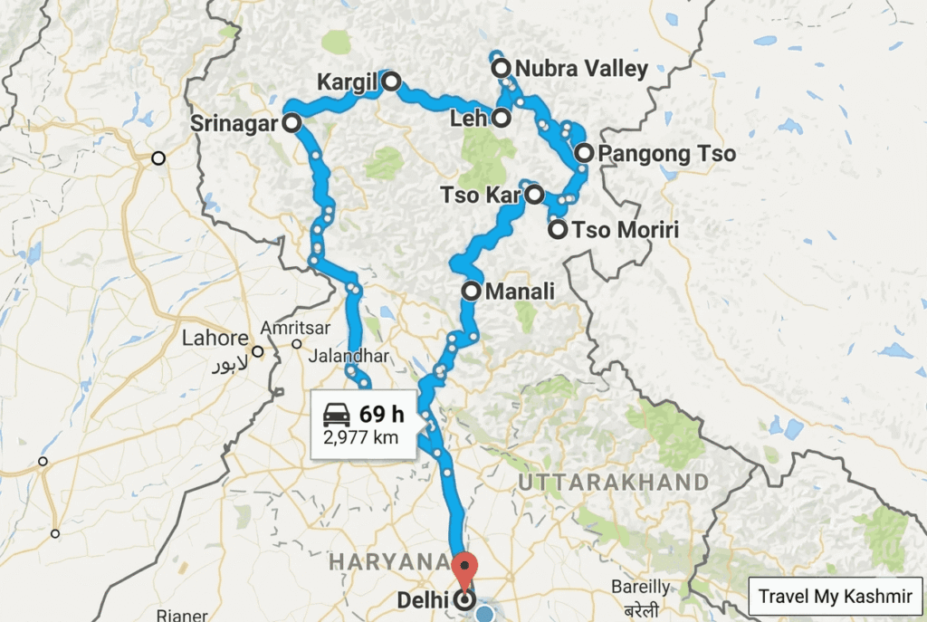
Major Routes to Ladakh: Srinagar vs Manali
The Srinagar to Leh Route (NH1)
Commonly referred to as the “civilized” route, the Srinagar-Leh highway is the preferred choice for first-timers. It offers a gradual increase in altitude, which is crucial for preventing Acute Mountain Sickness (AMS).
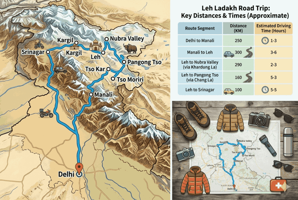
Total Distance: ~434 km
Duration: 2 days (with an overnight stay in Kargil)
Key Stops on the Route Map: * Sonamarg: Known as the “Meadow of Gold,” this is your last glimpse of lush Kashmiri greenery.
Zoji La Pass (11,575 ft): A thrilling, narrow pass that serves as the gateway to the Drass Valley.
Drass: The second coldest inhabited place on Earth and home to the Kargil War Memorial.
Kargil: The midpoint of the road map Ladakh travelers use for their first night’s halt.
Lamayuru: Famous for its “Moonland” landscapes and ancient monastery.
The Srinagar-Leh route is generally considered the easier and more accessible of the two main roads into Ladakh. Road surfaces are better maintained and the gradual altitude gain gives your body more time to acclimatise.
The Manali to Leh Route
For those seeking raw adrenaline, the Manali-Leh highway is the ultimate test. This route takes you through some of the highest motorable passes in the world and offers landscapes that look like another planet.
Total Distance: ~427 km (via Atal Tunnel)
Duration: 2 days (Recommended overnight stay in Jispa or Keylong)
Key Stops on the Route Map:
Atal Tunnel: A modern marvel that bypasses the Rohtang Pass, saving nearly 3-4 hours.
Jispa/Keylong: The best places to halt for the night to stay at a safer altitude.
Baralacha La (16,040 ft): A high mountain pass that often remains snow-covered even in peak summer.
Sarchu: The border between Himachal Pradesh and Ladakh.
Gata Loops: A series of 21 hairpin bends that will test your driving precision.
Tanglang La (17,480 ft): The highest point on this specific Ladakh route map before descending into Leh.
Route Comparison: Which one should you choose?
Scenery: Manali to Leh offers dramatic, barren, high-altitude desert views. Srinagar to Leh offers a mix of lush valleys and rugged mountains.
Difficulty: The Manali route is significantly tougher due to higher average altitudes and more remote stretches.
Acclimatization: Srinagar is the winner. Starting from Srinagar (1,585 m) and sleeping at Kargil (2,676 m) is much safer than the rapid ascent from Manali.
Detailed Road Map of Ladakh Region: Internal Routes
Once you reach Leh, the capital serves as your base camp. From here, your road map of Ladakh region branches out into three main directions: Nubra Valley, Pangong Tso and Tso Moriri.
Leh to Nubra Valley (via Khardung La)
- Distance: ~160 km
- Travel Time: 5–6 hours
- The Route: Leh → South Pullu → Khardung La → North Pullu → Khalsar → Diskit → Hunder.
- Highlight: Crossing Khardung La, once touted as the highest motorable road in the world (17,582 ft). Ensure you don’t spend more than 20 minutes at the top to avoid altitude-related issues.
The road to Nubra climbs over Khardung La often cited as one of the world’s highest motorable passes at 5,359 m. The descent into the Nubra Valley reveals sand dunes, the Shyok River and the famous double-humped Bactrian camels at Hunder. This route requires an Inner Line Permit (ILP)
Leh to Pangong Lake (via Chang La)
- Distance: ~160 km
- Travel Time: 5–6 hours
- The Route: Leh → Karu → Sakti → Chang La → Durbuk → Tangtse → Lukung → Spangmik.
- Highlight: The first glimpse of the deep blue Pangong water as you emerge from the mountains near Lukung.
Chang La (5,360 m) is the second major pass on this route. The road descends dramatically into the Shyok valley before reaching the mesmerising blue waters of Pangong Tso, a lake that straddles the India-China border. An ILP is mandatory. Overnight stays at the lake are popular and highly recommended.
Leh to Tso Moriri (The Remote Circuit)
- Distance: ~220 km
- Travel Time: 7–8 hours
- The Route: Leh → Karu → Upshi → Chumathang → Mahe → Sumdo → Korzok.
- Note: This route is less commercialized than Pangong. There are almost no fuel stations after Karu, so carrying extra fuel is mandatory.
Tso Moriri is the most remote of Ladakh’s three major lakes and often less crowded than Pangong. The route passes through Rupshu Plateau, where you might spot kiangs (wild asses) and Tibetan wolves. This route also needs an ILP and ideally a high-clearance vehicle.
Understanding the Mountain Passes on Your Road Map
Mountain passes (or “La” in the local language) are the backbone of any Ladakh route map. They are the highest points of your journey and require respect and preparation.
Zoji La (Srinagar-Leh): Known for its slushy roads and steep drops. It is the first major hurdle when coming from Kashmir.
Baralacha La (Manali-Leh): Often the reason the Manali highway opens late in the season due to heavy snow accumulation.
Khardung La (Leh to Nubra): The most iconic pass for bikers. It connects the Indus Valley to the Shyok and Nubra valleys.
Chang La (Leh to Pangong): Often considered tougher than Khardung La due to its steep ascent and unpredictable weather.
Fotu La (Srinagar-Leh): The highest point on the Srinagar-Leh highway, offering panoramic views of the Himalayan ranges.
How to Read a Ladakh Road Map
In the digital age, we rely on Google Maps, but in Ladakh, a physical or offline Ladakh route map is your best friend. A standard road map of Ladakh differs from most Indian road maps because of the unique terrain, restricted zones and infrastructure limitations. Here is how to navigate like a pro:
Connectivity and GPS
- The Reality Check: Data connectivity vanishes the moment you leave Leh city. Google Maps will not work unless you download offline maps in advance.
- The Best Network: Only Postpaid connections work in Ladakh. BSNL has the widest coverage in remote areas, followed by Airtel and Jio in Leh and Nubra.
Fuel Stations (The "Must-Know" Map Points)
Your road map Ladakh planning must center around fuel.
- Manali-Leh Highway: Tandi is your last reliable fuel station before Karu (near Leh). This is a stretch of roughly 365 km with zero official petrol pumps.
- Internal Routes: Always top up at the Leh petrol pump before heading to Nubra or Pangong. There is a small fuel station in Diskit (Nubra), but it often runs dry.
Checkpoints and Permits
You cannot simply drive anywhere. Areas like Nubra, Pangong and Tso Moriri require an Inner Line Permit (ILP) for Indian tourists and a Protected Area Permit (PAP) for foreigners. You must carry multiple physical copies of these permits to submit at various military checkpoints (North Pullu, South Pullu, Karu, etc.).
Travel Tips for a Successful Route Plan
The Best Time to Visit
The window for a road trip is narrow.
- June to September: This is the peak season. Both the Manali and Srinagar highways are open and the weather is pleasant.
- Late May: The roads usually open around this time, but expect massive snow walls and possible road closures due to melting snow.
Choosing Your Vehicle
Don’t trust just any car for the road map of Ladakh region.
- SUVs/4×4: Highly recommended for the Manali-Leh route and the Shyok river road.
- Bikes: Royal Enfield (350cc or 500cc) and Himalayan are the favorites for their torque and ability to handle rocky terrain.
- Ground Clearance: If you are taking a hatchback or sedan, be prepared for “underbelly hits” at Zoji La and various water crossings (nallahs).
Health and Acclimatization
Your Leh to Ladakh map should include a mandatory “buffer day” in Leh.
- Day 1 in Leh: Do nothing. Literally. Let your lungs adjust to the thin air (11,500 ft).
- Hydration: Drink 3-4 liters of water daily. Avoid alcohol and smoking during the first 48 hours.
Sample 10-Day Ladakh Route Map Itinerary
- Day 1: Arrive in Srinagar and relax.
- Day 2: Srinagar to Kargil (Stop at Sonamarg and Zoji La).
- Day 3: Kargil to Leh (Visit Lamayuru and Magnetic Hill).
- Day 4: Rest in Leh (Local sightseeing: Shanti Stupa, Leh Palace).
- Day 5: Leh to Nubra Valley (Via Khardung La).
- Day 6: Nubra Valley to Turtuk (The last village before the LAC).
- Day 7: Nubra to Pangong Tso (Via the adventurous Shyok Route).
- Day 8: Pangong Tso to Leh (Via Chang La).
- Day 9: Leh to Tso Moriri (Optional long drive for lake lovers).
- Day 10: Depart from Leh (Fly out or take the Manali highway back).
Explore and Book Leh Ladakh Tour Packages here
Frequently Asked Questions (FAQs)
What is the best route to Ladakh for a first-timer?
The Srinagar to Leh route is the best for first-timers. It offers a more gradual altitude gain, better road conditions and plenty of stops for food and fuel, making it easier for the body to acclimatize.
Which road map is best for a Ladakh trip?
While Google Maps (Offline) is helpful, a physical road map of Ladakh from a local Leh travel agent or a detailed guide like this one is superior. Local maps mark specific “nallahs” (water crossings) and seasonal BRO (Border Roads Organization) checkpoints that digital maps might miss.
Can I travel Ladakh without a map?
It is highly discouraged. Between the lack of mobile signals, confusing forks in remote valleys and the critical distance between fuel stations, traveling without a pre planned Ladakh route map is risky.
Is the Atal Tunnel open for tourists going to Leh?
Yes, the Atal Tunnel is the primary gateway for travelers on the Manali-Leh highway. It bypasses the Rohtang Pass, reducing the distance by about 46 km and significantly shortening travel time.
Final Thoughts
A trip to Ladakh is as much about the journey as it is about the destination. By studying your Ladakh route map and understanding the nuances of the road map of Ladakh region, you aren’t just planning a vacation, you are preparing for an expedition. Respect the mountains, keep your fuel tank full and always carry a physical map to navigate the land where the earth meets the sky.